Talk:West Monroeville
AUTOMAPPING
Alex DeWitt of the DEM has made an AutoMapping extension - please download it and check the current results here (note that the map is updated from the results every five minutes and you may have to allow ud-malton.info to install the addon before it works) --xensyriaT 06:25, 27 February 2008 (UTC)
Barricade Question
Because zombies dont have memories of life yet wouldnt it be better to keep the cades low and just close the doors so we dont give the zombies free XP.
--JleggittMR 16:23, 25 February 2008 (UTC)
Genius! Also, close the doors of uninhabited buildings. No-genius 10:02, 26 February 2008 (UTC)
- I just watched a zed open a door in W. Monroeville!!! --Hungrygrok 18:40, 26 February 2008 (UTC)
- It's wise to shut doors. Barricading is good for survivors, but also gives XP to zombies and alerts them to your location (since most buildings are still unbarricaded). Barricade if you need to, but don't be overzealous just yet unless you're aware of a presence in your area. We haven't yet reached the quickening point for the Memories of Life skill, but the gap between now and then is getting smaller every hour. Also be aware that zombies can and will farm XP from each other in order to level quickly. Watch your surroundings and try not to sleep alone. --ViperBait 19:10, 26 February 2008 (UTC)
Maps
Alex DeWitt of the DEM has made an AutoMapping extension - please download it, check and incorporate the current results from there (note that the map is updated from the results every five minutes and you may have to allow ud-malton.info to install the addon before it works)
I have updated and completed all the mapping and have added links to them on the main page as well as below. Let me know what you think.
--Jianta
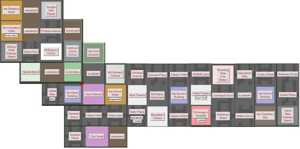
The maps are divided up and fit together in the following way:
| Northwest | Northeast |
| Central West | Central East |
| Southwest | Southeast |
Northwest
Northeast
Central West
- bottom row is still not showing up
Central East
- bottom row is still not showing up.
Mapes Row Fire Station is actually firther south, the one on central east is in fact bradfield Lane Fire Department 365,21 --RosslessnessWant a Location Image? 13:29, 2 March 2008 (UTC)
- all fixed
Southwest
South East
Thank You!
I didn't get all this map information myself!!
Thank you to everyone who sent me information or posted it here-especially:
Theokrat, Sir Fred of Etruria, Jelly Roll Morton, Co fragment, Peter Doe, DonTickles, Mikelietz, Goldrush, SteveInPA, Adrian Benning, Karek, Punkrockrevel, and Barnoid.
~~Jianta
Monroeville Many
Just a quick thing to say good luck to you humans in the suburb. Hopefully once this area picks up a bit we'll both have a good fight on our hands. As I said, watch your 'cades, they're very low, and the first thing I'm getting it Memories of Life. On my travels I'll see if I can add something to the map resource buildings and contribute to the news section of the suburb while maintaining a NPOV. Hope to see you about the suburb soon enough! Acoustic Pie 21:23, 25 February 2008 (UTC)
Map Chat
i figure we should try to get a map together. Please add any strip of land you find as a new map, or if you can see the connection to another point add it there. If you have any coordinates or if you hit the edge of the map, tell so. --Theokrat
I am working on a large update --Jianta
a spreadsheet of my meanderings in the West [1] --Mikelietz 19:28, 25 February 2008 (UTC)
I would like to conribute to the cause. Sir Fred of Etruria
- I hit the Northern border of Munroeville while still in West Munroeville. I've got an Excel Spreadsheet that I'm converting to CSV in order to building something I can upload at the moment. West Munroeville is apparently 45 blocks from top to bottom. It is bordered on the North by the Quarantine Zone, on the East by Central Munroeville, and on the South by South Munroeville. I assume the western border is the game boundary.
Also here is an Iwitness that I have captured http://iwrecords.urbandead.info/02-25-08_1500hrs_PUBLIC/IN_99-5_West_Monroevill_c0e-a5f-b65.html
Here is a little map I created (The NE corner of the mall is at [65,5]: http://img526.imageshack.us/my.php?image=monrmapkb3.png Peter Doe 18:52, 25 February 2008 (UTC)
- The east border of West Munroeville is at [369,1 - 369,45]
- The south border of West Munroeville is from [??, 45 - 369,45] --Goldrush 20:55, 25 February 2008 (UTC)
- The west border of West Monroeville is North Oakvale Sir Fred of Etruria
- There are reports of the north border to be exactly at 1, big surprise, the western border starts at 340, so our place here is 30 blocks wide, and aprently 45 blocks in height...--Theokrat 22:56, 25 February 2008 (UTC)
Anyone have a coordinate for ANY building/location on the current top map? I have a full map going and am not sure where to plug it in. --Jianta
my contribution contains some of West Monroeville, from the border at 340-1 to the mall at 365-5, you can see much of Oak Hill there too. [2] I've got to run, so if someone else could work on converting to the maps below that would be great.--DonTickles 23:20, 25 February 2008 (UTC)
http://img.photobucket.com/albums/v180/TheUncleBob/minimap.jpg
So if the limits are 45, why not take as a working start 9 squares of 15x15 and map them "seperatly".
So 1 15x15 map for each the NE, N, NW, E, center, W, SW, S, SE.
That way each of the maps is still overlookable and we can work on them...
Edit: or maybe "upper right", "lower left", etc. to avoid confusion --Theokrat 22:21, 25 February 2008 (UTC)
Once we know how the maps connect that is a plan! Once I can get the coordinates from a building in the top map I will add it to my coordinate grid and I can split it --Jianta
- St Judes Hospital is 349-23 , so the maps should already touch each other (or i am a number retard)--Theokrat 22:38, 25 February 2008 (UTC)
- Thanks! I will update in a minute--Jianta
Just a small piece of the West MV jigsaw near Benepe Street - --Co fragment 23:32, 25 February 2008 (UTC) http://wiki.urbandead.com/index.php/Image:South_of_benepe_st.jpg
seems to be a few errors on some of the info being sent to me, please make sure you double check! I will have them fixed as soon as I can --Jianta
- I've added a lot to the spreadsheet I linked before. It's very close to being linkable with Monroeville/map (and South Monroeville, for that matter).--Mikelietz 05:54, 26 February 2008 (UTC)
- I'm encountering an error. I mapped Vawter Road to be 2N of Biddle Avenue. My map isn't meshing at that point. What should I do with my raw data? I'm putting in my somewhat shifted observation anyway. When someone figures out what happened, they can add or remove a cell and shift stuff around. Sorry! SteveInPA 06:34, 26 February 2008 (UTC)
- Well, i figured out where to put my personal raw data. Its in my user page. Anyone can feel free to tell me where i screwed up. SteveInPA 06:52, 26 February 2008 (UTC)
- I'm encountering an error. I mapped Vawter Road to be 2N of Biddle Avenue. My map isn't meshing at that point. What should I do with my raw data? I'm putting in my somewhat shifted observation anyway. When someone figures out what happened, they can add or remove a cell and shift stuff around. Sorry! SteveInPA 06:34, 26 February 2008 (UTC)
- I've added a lot to the spreadsheet I linked before. It's very close to being linkable with Monroeville/map (and South Monroeville, for that matter).--Mikelietz 05:54, 26 February 2008 (UTC)
- You didn't screw up- one of the sources mis numbered their grid- I am in the process of trying to fix that. Thanks! --Jianta
- well, I scouted again and figured out the problem. I adjusted the map as such: (Northeast - shifted the last row 1W east of St Charles's Hospital and the second to last 1W east of Goshorn Towers. it should line up right now. I think.) SteveInPA 05:58, 27 February 2008 (UTC)
- graphical mapping goodness in my profile for reference! SteveInPA 06:21, 27 February 2008 (UTC)
- well, I scouted again and figured out the problem. I adjusted the map as such: (Northeast - shifted the last row 1W east of St Charles's Hospital and the second to last 1W east of Goshorn Towers. it should line up right now. I think.) SteveInPA 05:58, 27 February 2008 (UTC)
- You didn't screw up- one of the sources mis numbered their grid- I am in the process of trying to fix that. Thanks! --Jianta
about the north and east border - in another "suburb" though - Central MV - see User:Duke Garland/Monroe. I also strongly recomend to add the coordinates rows/columns as i did to all maps. If not you - eventually i'll do it myself --~~~~ [talk] 09:25, 26 February 2008 (UTC)
COORDIANTE NOTE: Using a GPS gives the coordinates for Archway Mall as 65,5. So it looks like we drop the 3. (previous coordinates obtained from source) --Jelly Roll Morton 15:44, 26 February 2008 (UTC)
- The more I think about it, it makes more sense to leave it in the 300 range. That's the source, and I'm not even sure if the GPS is able to display 3 digits.--Jelly Roll Morton 17:26, 26 February 2008 (UTC)
Update
After waking up in west monroeville, i took a stroll. Luckily i was able to find the northern border. Please add this info to your map as you see fit, i'm not too good with code and stuff so ... yeah.
anyway here's the map Image:Monroepath.jpg
Hope it helps.
--Adrian Benning 09:45, 26 February 2008 (UTC)
- I've turned the image into a link as it was forcing expanding of the page, which is a bad thing.--Karekmaps?! 00:09, 27 February 2008 (UTC)
This is a map of the area I've been operating out of. It's in South Monroeville. We have a small thing going at the Eugene Hospital. I was sent north to try and find a mall that was someone rumored about. I'm sposed to be going back with the information. I'm not sure where this fits on your maps, but do with it as you will.
http://img254.imageshack.us/img254/7589/monroemap1go6tc9.jpg
I'm getting a database ready. The top-left corner of where I've scouted is St. Eliguis's Church, I'll finish off my moves then upload it here, 'cause I'm crap at wiki editing and would rather not screw it up.
G'luck, all. Punkrockrevel
   --Link to it here; http://www.megaupload.com/?d=AIJ5J8VL
     It's an OpenOffice file (.ops), I'm sorry :/ if anyone can make any use of it, though, great.
If someone has the time, this minimap will fill in the top right part of the SW part of West Monroeville
http://wiki.urbandead.com/index.php/Image:Untitled3cf.jpg
OKay, i made what i promised for Central Monroeville... oh, i didn't write it here, eh?... well, i've parsed the current maps we had into my database and querried it out all in 1 big map. you can see it here>>> User:Duke Garland/Monroe <<<here. I'm going to add all your west Monroeville maps there now too. i can also make so that it would bypass wiki - just a map through the URL --~~~~ [talk] 21:41, 26 February 2008 (UTC)
We seem to have come up against the template expansion limit: http://en.wikipedia.org/wiki/Wikipedia_talk:Template_limits Which is why the map table cells are becoming broken. --Barnoid 21:46, 26 February 2008 (UTC)
Damnit. Did not even know such a thing was possible. So what now? --Theokrat 22:13, 26 February 2008 (UTC)
I suppose the maps will go on separate pages at some point so it will stop being a problem. We just need to work out what kind of wiki layout Monroeville needs. For now I reckon we keep mapping as it's only a display thing. --Barnoid 23:49, 26 February 2008 (UTC)
Don't worry about the template size limit, it's manageable by splitting them up into parts then calling it through another template(as the include size is only the immediate template being called through {{Template}}, not any templates that template calls.)--Karekmaps?! 00:09, 27 February 2008 (UTC)
subdivision template
Hey, so i made a small template (Template:Subdivision_map) for a 15x15 grid. Still needs improvements, but i think its usable. Example is on my userpage with just a couple of entries.
--Theokrat 10:01, 26 February 2008 (UTC)
Who else is working on this?
Post your sig here, so we can give credit where credit is due, as this project is a huge task!
- Jianta
- Chelsea Dagger
- Theo
- Erik
- Ren Sixtus
- SteveInPA
- ViperBait
- Alan Watts
- Jordan Salafack
- Peter Doe
- Boris
Subdivision articles
the SW_subdivision_of_West_Monroeville now has its own stub, including the map. Tell me what you think --Theokrat 12:12, 27 February 2008 (UTC)
So, shall we go on and get the other corners their own articles as well? --Theokrat 15:48, 28 February 2008 (UTC)
Zombies
There seems to be large amount of zombies (for this place), certainly more than anyware else.
Blame the Monroeville Many for their extremely fast and coordinated strikes against harmanz. Watch out all you still warm bodies! --Justin 05:23, 9 March 2008 (UTC)
united map
i've made a huge update to my united map: top half, bottom half. if you have data lacking there - i'll be glad to parse it in. i'm also looking forward to parse out any sub-blocks of the map in any suitable format to be placed on wiki pages. --~~~~ [talk] 00:10, 29 February 2008 (UTC)
- if nothing will be distracting me - i'll be parsing out maps for you soon --~~~~ [talk] 16:16, 2 March 2008 (UTC)
Mobile Phone Mast
I'm not sure if there are more than one for the whole of West Monroeville, however in the north East Section there is one in Club Petet, just south of Archway Mall. I'm not sure whether or not it is the one for the whole of West Monroeville, but given the size of the suburb, I doubt it is. Acoustic Pie 16:40, 2 March 2008 (UTC)
Alternate Radio Frequencies
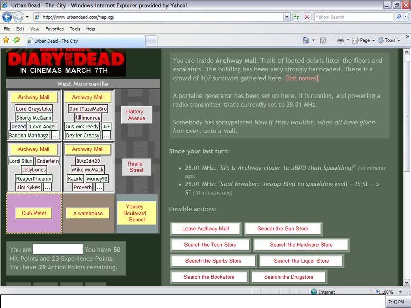
- Archway Mall has radios set to 28.01 MHz. Pic http://i26.photobucket.com/albums/c149/IRMacGuyver/radio.jpg (IRMacGuyver 00:48, 15 March 2008 (UTC))
Zombie horde
20 zombies and 30 bodies in James hostpital in West monroeville. It is ruined. —The preceding unsigned comment was added by Warlord_zephyr (talk • contribs) 20:55, 16 March 2008.
Basic Map gone
It is now just replaced with a small picture, lacking linsk to the other adjacent suburbs.--Kolechovski 18:20, 25 March 2008 (UTC)
- Yes, but that is temporally --~~~~ [talk] 19:45, 25 March 2008 (UTC)
- Tis better now, but could we somehow blow up the picture a bit? That text is insanely small...--Kolechovski 18:49, 29 March 2008 (UTC)
Proposed Barricade Plan
Map Legend: Yellow=VSB building, Red=EHB building, Blue=VSB if the area is relatively safe, or EHB if dangerous
West Monroeville Barricade Plan: http://img119.imageshack.us/my.php?image=westmonroevillecadeplania9.gif
Does everybody likey?--Kolechovski 23:44, 1 April 2008 (BST)