Gainard Place Police Department: Difference between revisions
From The Urban Dead Wiki
Jump to navigationJump to search
AndyMatthews (talk | contribs) No edit summary |
AndyMatthews (talk | contribs) |
||
| (2 intermediate revisions by the same user not shown) | |||
| Line 14: | Line 14: | ||
SE_location=[[Stoodely Street]]|SE_color=Street| | SE_location=[[Stoodely Street]]|SE_color=Street| | ||
}} | }} | ||
[[File:Mpd.png|150px]] | |||
This [[Building Types#Police Department|police station]] is located in the eastern part of [[Lamport Hills]]. It has been designated VSB+2 in the Lamport Hills barricade plan. [[Tagging]] it earns no XP. | This [[Building Types#Police Department|police station]] is located in the eastern part of [[Lamport Hills]]. It has been designated VSB+2 in the Lamport Hills barricade plan. [[Tagging]] it earns no XP. | ||
| Line 23: | Line 24: | ||
<br style="clear: both" /> | <br style="clear: both" /> | ||
==Malton Department of Emergency Management Information== | |||
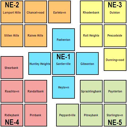
[[Lamport Hills]] is in District Two of the [[Department of Emergency Management#NE Division|Northeast Division]] of the Department of Emergency Management. | |||
[[File:DEM NE.JPG|DoEM NE Division Two]] | |||
---- | ---- | ||
Latest revision as of 06:45, 23 October 2024
| Gainard Place Police Department EHB, dark. AndyMatthews (talk) 01:14, 12 October 2024 (UTC)
|
| Gainard Place Police Department
Lamport Hills [58,5]
Basic Info:
|
 This police station is located in the eastern part of Lamport Hills. It has been designated VSB+2 in the Lamport Hills barricade plan. Tagging it earns no XP.
History
Current Status
December 21st, 2007 RUINED! EASY! EASY! EASY! --Talunex 17:21, 21 December 2007 (UTC)
Malton Department of Emergency Management Information
Lamport Hills is in District Two of the Northeast Division of the Department of Emergency Management.
| This page, Gainard Place Police Department, is a locations stub. Please help us to improve the wiki by contributing to this page. Be sure the following information is added to the page: coordinates, suburb, 9 block map (or 16 block map for large buildings), description, barricading policy, and history. Please refer to the Location Style Guide. |

