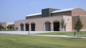
Councell Lane Fire Station: Difference between revisions
From The Urban Dead Wiki
Jump to navigationJump to search
AndyMatthews (talk | contribs) (Changing to PAGENAME.) |
|||
| Line 1: | Line 1: | ||
{{User:DangerReport/{{PAGENAME}}}} | |||
{{Locationblock| | {{Locationblock| | ||
suburb=West Grayside| | suburb=West Grayside| | ||
| Line 13: | Line 13: | ||
S_location=[[the Wilson Museum]]|S_color=Museum| | S_location=[[the Wilson Museum]]|S_color=Museum| | ||
SE_location=[[St. Timothy's Church (West Grayside)|St. Timothy's Church]]|SE_color=Church|}} | SE_location=[[St. Timothy's Church (West Grayside)|St. Timothy's Church]]|SE_color=Church|}} | ||
__NOTOC__ | |||
=Description= | =Description= | ||
[[Image:Fire_department.JPG|left|300px]] | [[Image:Fire_department.JPG|left|300px]] | ||
Revision as of 06:52, 8 October 2024
| Councell Lane Fire Station EHB++ Sushieraser (talk) 01:33, 18 July 2021 (UTC)
|
| Councell Lane Fire Station
West Grayside [50, 82] Basic Info:
|
Description
Barricade Policy
In accordance with the West Grayside Barricade Plan, this site is to be kept at Very Strongly Barricaded (VSB+2), in order to permit entry by rookies and those needing Free Running access.
Current Status
6th July 2020 - Overcaded at VHB. Mafiamanz (talk) 16:28, 6 July 2020 (UTC)
History
| This page, Councell Lane Fire Station, is a locations stub. Please help us to improve the wiki by contributing to this page. Be sure the following information is added to the page: coordinates, suburb, 9 block map (or 16 block map for large buildings), description, barricading policy, and history. Please refer to the Location Style Guide. |
