File:Printable Map of Malton.png

Original file (798 × 1,047 pixels, file size: 96 KB, MIME type: image/png)
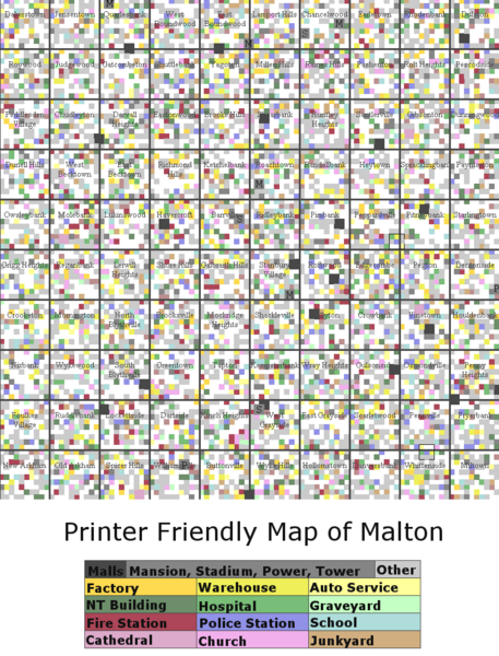
This map is "printer friendly" in that it has a high enough resolution to print well, but is small enough in terms of memory to print quickly. The colors on this map are NOT the "Malton Standard Colors" you would see on your game screen or on most web maps. Instead, the colors are selected to print nicely without using up to much ink, and to use roughly equal amounts of each ink color. The light colors also make it easier to see notes you make on the map. Hopefully they are also logical choices; yellow and brown for industrial zones, green for health zones, red for fire, blue for police and school, purple for church.
Using this map is simple; click on the image above to open it in its own browser window. Then print it out, being sure to use the portrait mode and "shrink to fit" settings.
. . . swiers ![]() 18:18, 3 July 2007 (BST)
18:18, 3 July 2007 (BST)
File history
Click on a date/time to view the file as it appeared at that time.
| Date/Time | Thumbnail | Dimensions | User | Comment | |
|---|---|---|---|---|---|
| current | 18:03, 3 July 2007 | | 798 × 1,047 (96 KB) | Swiers (talk | contribs) | <big>'''This map is "printer friendly" in that it has a high enough resolution to print well, but is small enough in terms of memory to print quickly. The colors on this map are NOT the "Malton Standard Colors" you would see on your game screen or on mos |
| 16:53, 3 July 2007 |  | 798 × 1,047 (96 KB) | Swiers (talk | contribs) | A printer friendly map of Malton. Shows entire city, with suburb names and most building types color coded or IDed. |
You cannot overwrite this file.
File usage
The following page uses this file: