Farrant Crescent Police Department: Difference between revisions
From The Urban Dead Wiki
Jump to navigationJump to search
No edit summary |
AndyMatthews (talk | contribs) |
||
| (15 intermediate revisions by 4 users not shown) | |||
| Line 1: | Line 1: | ||
{{User:DangerReport/{{PAGENAME}}}} | |||
{{Locationblock| | {{Locationblock| | ||
suburb=Shearbank| | suburb=Shearbank| | ||
| Line 12: | Line 13: | ||
S_location=[[Junkyard 55,22|a junkyard]]|S_color=Junkyard| | S_location=[[Junkyard 55,22|a junkyard]]|S_color=Junkyard| | ||
SE_location=[[Borde Bank]]|SE_color=Bank}} | SE_location=[[Borde Bank]]|SE_color=Bank}} | ||
[[File:Mpd.png|150px]] | |||
[[Image: | [[Image:MaltonPoliceStation.jpg|thumb|right|[[Malton Police Department]]]] | ||
== Description == | |||
=== Description === | |||
Farrant Crescent Police Dept (55,21) is situated in northern [[Shearbank]]. | Farrant Crescent Police Dept (55,21) is situated in northern [[Shearbank]]. | ||
The closest [[NecroTech]] building is [[the Whippey Building]] at (53,22). The closest Revive Point is [[Allder Row]] at (53,21). | The closest [[NecroTech]] building is [[the Whippey Building]] at (53,22). The closest Revive Point is [[Allder Row]] at (53,21). | ||
[[ | === Barricade Policy === | ||
According to the [[Shearbank Barricade Plan]], Farrant Crescent Police Department should be kept '''EHB''' at all times. | |||
Nearest entry points are: | |||
*[[Holroyd Bank]] (56,20) | *[[Holroyd Bank]] (56,20) | ||
*[[St. Christopher's Church (Shearbank)|St. Christopher's Church]] (54,22) | *[[St. Christopher's Church (Shearbank)|St. Christopher's Church]] (54,22) | ||
*[[Edmund General Hospital (Shearbank)|Edmund General Hospital]] (53,20) | *[[Edmund General Hospital (Shearbank)|Edmund General Hospital]] (53,20) | ||
== Tagging == | === Tagging === | ||
Should be tagged with directions towards entry points. | |||
Tagging this building yields 2 [[XP]]. | |||
==Malton Department of Emergency Management Information== | |||
[[Shearbank]] is in District Four of the [[Department of Emergency Management#NE Division|Northeast Division]] of the Department of Emergency Management. | |||
[[File:DEM NE.JPG|DoEM NE Division Four]] | |||
[[Category:Shearbank]] | [[Category:Shearbank]] | ||
[[Category:Police Departments]] | [[Category:Police Departments]] | ||
Latest revision as of 07:35, 23 October 2024
| Farrant Crescent Police Department |
| Farrant Crescent Police Department
Shearbank [55,21]
Basic Info:
|
Description
Farrant Crescent Police Dept (55,21) is situated in northern Shearbank.
The closest NecroTech building is the Whippey Building at (53,22). The closest Revive Point is Allder Row at (53,21).
Barricade Policy
According to the Shearbank Barricade Plan, Farrant Crescent Police Department should be kept EHB at all times.
Nearest entry points are:
- Holroyd Bank (56,20)
- St. Christopher's Church (54,22)
- Edmund General Hospital (53,20)
Tagging
Should be tagged with directions towards entry points.
Tagging this building yields 2 XP.
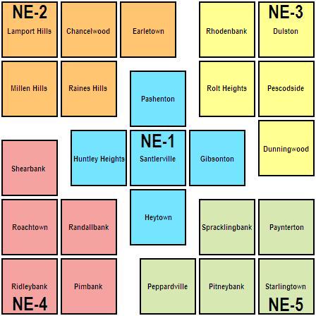
Malton Department of Emergency Management Information
Shearbank is in District Four of the Northeast Division of the Department of Emergency Management.


