Central Borehamwood: Difference between revisions
(→Suburb Map: minor test) |
(→Suburb Map: adding (mostly without colors at this point)) |
||
| Line 292: | Line 292: | ||
location0221=[[Fredrick Park]]|location0221_color=park| | location0221=[[Fredrick Park]]|location0221_color=park| | ||
location0222=[[a carpark]]|location0222_color=carpark| | location0222=[[a carpark]]|location0222_color=carpark| | ||
location0301= | location0301=The Tap and Spile| | ||
location0302=Lenox Road Police Station| | location0302=Lenox Road Police Station|location0302_color=Police Dept| | ||
location0303=Sheppard Square|location0303_color=street| | location0303=Sheppard Square|location0303_color=street| | ||
location0304=The Rising Sun| | location0304=The Rising Sun| | ||
location0305=| | location0305=Gammon Walk Police Station|location0305_color=Police Dept| | ||
location0306=| | location0306=The Pitcher Museum| | ||
location0307=| | location0307=Whitcombe Walk|location0307_color=Street| | ||
location0308=| | location0308=| | ||
location0309=| | location0309=| | ||
| Line 314: | Line 314: | ||
location0321=[[Care Towers]]|location0321_color=tower| | location0321=[[Care Towers]]|location0321_color=tower| | ||
location0322=[[Campain Road]]|location0322_color=street| | location0322=[[Campain Road]]|location0322_color=street| | ||
location0401=| | location0401=Sires Street| | ||
location0402=| | location0402=the Clanfield Building| | ||
location0403=| | location0403=Saltford Towers| | ||
location0404=| | location0404=[[wasteland]]| | ||
location0405=| | location0405=the Grimes Monument| | ||
location0406=| | location0406=the Goverd Building| | ||
location0407=| | location0407=| | ||
location0408=| | location0408=| | ||
| Line 336: | Line 336: | ||
location0421=[[The Valentine Building]]|location0421_color=building| | location0421=[[The Valentine Building]]|location0421_color=building| | ||
location0422=[[Marshalsey Bank]]|location0422_color=bank| | location0422=[[Marshalsey Bank]]|location0422_color=bank| | ||
location0501=| | location0501=Batt Walk| | ||
location0502=| | location0502=the Chorley Hotel| | ||
location0503=| | location0503=Snell Park| | ||
location0504=| | location0504=Sellwood Place Fire Station|location0504_color=Fire Station| | ||
location0505=| | location0505=| | ||
location0506=| | location0506=| | ||
| Line 358: | Line 358: | ||
location0521=| | location0521=| | ||
location0522=| | location0522=| | ||
location0601=| | location0601=Membry Way| | ||
location0602=| | location0602=the Tredaway Building| | ||
location0603=| | location0603=| | ||
location0604=| | location0604=| | ||
| Line 380: | Line 380: | ||
location0621=| | location0621=| | ||
location0622=| | location0622=| | ||
location0701=| | location0701=[[a warehouse]]| | ||
location0702=| | location0702=Parkin Place Police Station|location0702_color=Police Dept| | ||
location0703=| | location0703=| | ||
location0704=| | location0704=| | ||
| Line 402: | Line 402: | ||
location0721=| | location0721=| | ||
location0722=| | location0722=| | ||
location0801=| | location0801=Eagan Road| | ||
location0802=| | location0802=Ruffer Towers| | ||
location0803=| | location0803=| | ||
location0804=| | location0804=| | ||
| Line 424: | Line 424: | ||
location0821=| | location0821=| | ||
location0822=| | location0822=| | ||
location0901=| | location0901=[[wasteland]]| | ||
location0902=| | location0902=[[a carpark]]| | ||
location0903=| | location0903=Club Camidge| | ||
location0904=| | location0904=| | ||
location0905=| | location0905=| | ||
| Line 446: | Line 446: | ||
location0921=| | location0921=| | ||
location0922=| | location0922=| | ||
location1001=| | location1001=Thom Street| | ||
location1002=| | location1002=St. Onuphrius's Hospital|location1002_color=hospital| | ||
location1003=| | location1003=Broad Crescent| | ||
location1004=| | location1004=Bobbett Road| | ||
location1005=| | location1005=House Grove| | ||
location1006=| | location1006=St. Servatius's Church| | ||
location1007=| | location1007=Purt Avenue| | ||
location1008=| | location1008=Hayler Gardens| | ||
location1009=| | location1009=Briggs Library| | ||
location1010=| | location1010=Hunn Road| | ||
location1011=| | location1011=the Radcliffe Arms| | ||
location1012=| | location1012=Mallard Square Police Station|location1012_color=Police Dept| | ||
location1013=| | location1013=Marke Row| | ||
location1014=| | location1014=the Lathey Building| | ||
location1015=| | location1015=St. Antheros's Church| | ||
location1016=| | location1016=[[a cemetary]]| | ||
location1017=| | location1017=Meetcham Lane Fire Station|location1017_color=Fire Station| | ||
location1018=| | location1018=| | ||
location1019=| | location1019=| | ||
Revision as of 04:08, 29 October 2008
| Suburb of Central Borehamwood | ||||||||||||||||||||||||||||||||||||||||||||||||||||||||||||||||||||||||||||||||||||||||||||||||||||||
| ||||||||||||||||||||||||||||||||||||||||||||||||||||||||||||||||||||||||||||||||||||||||||||||||||||||
| Update Central Borehamwood's Danger Level | ||||||||||||||||||||||||||||||||||||||||||||||||||||||||||||||||||||||||||||||||||||||||||||||||||||||
|
| ||||||||||||||||||||||||||||||||||||||||||||||||||||||||||||||||||||||||||||||||||||||||||||||||||||||
| View Danger Center | ||||||||||||||||||||||||||||||||||||||||||||||||||||||||||||||||||||||||||||||||||||||||||||||||||||||
| ||||||||||||||||||||||||||||||||||||||||||||||||||||||||||||||||||||||||||||||||||||||||||||||||||||||
| ||||||||||||||||||||||||||||||||||||||||||||||||||||||||||||||||||||||||||||||||||||||||||||||||||||||
Known groups in this suburb:
Key buildings in Central Borehamwood:
| ||||||||||||||||||||||||||||||||||||||||||||||||||||||||||||||||||||||||||||||||||||||||||||||||||||||
| Suburb Number: 45 |

|
Please remember to keep this article neutral. |
Central Borehamwood is a suburb of Borehamwood.
Resource Buildings
|
Fire Stations |
Hospitals |
|
NecroTech Facilities {{{NTs}}} |
Police Departments |
|
Malls |
Bulletin Boards |
|
Revive Points |
Paynterton Radio
Recent News
Please: recent news at the top (signed & NPOV). Old news can be archived.
October 2008
October 28 2008
Let's get a map up here ASAP. --Willdobbins
- these 8 iwitty - done @ User:Duke Garland/BHW --~~~~ [talk] 22:17, 28 October 2008 (UTC)
Yes, I am pretty abandoning Malton. BWAHAHA!! MORE MAPPING!!--Jen 21:21, 28 October 2008 (UTC)
- I went roughly along the northern edge of Central BW, finishing in West BW. Now we can figure out that the width of Central Borehamwood is 22! (My map ties nicely into the suburb map below, connecting point is Monica General Hospital). --Tybalt Peroni 21:34, 28 October 2008 (UTC)
--Let's try filling in the new map. I can easily edit the template if we find the suburb has different dimensions than 22x22--Brad Karlin
- I can't get Iwitness to work for me. If I post some screenshots is that going to help? Is there a page somewhere where all the mapping is being centralized? - tylerisfat 22:56, 28 October 2008 (UTC)
- We'll need to make a brand new template, most likely based off Template:EXP_Suburbblock. First we need to know dimensions of the suburbs. Let's hope they're all the same size. --Tybalt Peroni 23:59, 28 October 2008 (UTC)
- An set of iwitness snapshots, walking south along the western border of Central BHW. I didn't get all the way to southwestern corner... Yet. --Tybalt Peroni 00:25, 29 October 2008 (UTC)
[1] [2] [3] [4] [5] [6] [7] [8] [9] [10] [11] [12] [13] [14] [15] [16] [17] [18] [19] [20]
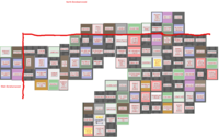
Suburb Map
Suburb Map
--Assuming that Central Borehamwood is 22x22, here is a 22x22 map. Knock yourselves out filling in the info from screenshots.--

