Central Borehamwood
| Suburb of Central Borehamwood | ||||||||||||||||||||||||||||||||||||||||||||||||||||||||||||||||||||||||||||||||||||||||||||||||||||||
| ||||||||||||||||||||||||||||||||||||||||||||||||||||||||||||||||||||||||||||||||||||||||||||||||||||||
| Update Central Borehamwood's Danger Level | ||||||||||||||||||||||||||||||||||||||||||||||||||||||||||||||||||||||||||||||||||||||||||||||||||||||
|
| ||||||||||||||||||||||||||||||||||||||||||||||||||||||||||||||||||||||||||||||||||||||||||||||||||||||
| View Danger Center | ||||||||||||||||||||||||||||||||||||||||||||||||||||||||||||||||||||||||||||||||||||||||||||||||||||||
| ||||||||||||||||||||||||||||||||||||||||||||||||||||||||||||||||||||||||||||||||||||||||||||||||||||||
| ||||||||||||||||||||||||||||||||||||||||||||||||||||||||||||||||||||||||||||||||||||||||||||||||||||||
Known groups in this suburb:
Key buildings in Central Borehamwood:
| ||||||||||||||||||||||||||||||||||||||||||||||||||||||||||||||||||||||||||||||||||||||||||||||||||||||
| Suburb Number: 45 |

|
Please remember to keep this article neutral. |
Central Borehamwood is a suburb of Borehamwood.
Resource Buildings
|
Fire Stations |
Hospitals |
|
NecroTech Facilities {{{NTs}}} |
Police Departments |
|
Malls |
Bulletin Boards |
|
Revive Points |
Paynterton Radio
Recent News
Please: recent news at the top (signed & NPOV). Old news can be archived.
October 2008
October 29 2008
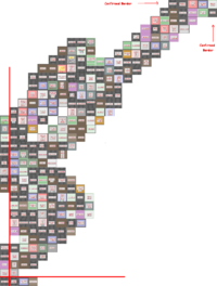
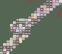
Here is my poor attempts to make a hand made map. This can be useful in some way, also, this region on my map is more more southier than Tikhon General Hospital. http://img395.imageshack.us/img395/5416/pylyuh5.gif --Pheen 11:28, 29 October 2008 (UTC)
Here's a quick & dirty merge of my map and Jen's, it gives us the full NE to SW diagonal. I'm not 100% sure about the southern limit cause I got it from the western side, but I'm pretty sure it's 33 blocks.--Zolt 11:59, 29 October 2008 (UTC)
October 28 2008
Let's get a map up here ASAP. --Willdobbins
- these 8 iwitty - done @ User:Duke Garland/BHW --~~~~ [talk] 22:17, 28 October 2008 (UTC)
Yes, I am pretty abandoning Malton. BWAHAHA!! MORE MAPPING!!--Jen 21:21, 28 October 2008 (UTC)
- Screenshot transcribed into the 22x22 map, thanks! --Tybalt Peroni 10:38, 29 October 2008 (UTC)
- I went roughly along the northern edge of Central BW, finishing in West BW. Now we can figure out that the width of Central Borehamwood is 22! (My map ties nicely into the suburb map below, connecting point is Monica General Hospital). --Tybalt Peroni 21:34, 28 October 2008 (UTC)
- This screenshot has now been transcribed onto the new 22x22 map, I'm going to do Jen's now. --Tybalt Peroni 10:01, 29 October 2008 (UTC)
--Let's try filling in the new map. I can easily edit the template if we find the suburb has different dimensions than 22x22--Brad Karlin
- I can't get Iwitness to work for me. If I post some screenshots is that going to help? Is there a page somewhere where all the mapping is being centralized? - tylerisfat 22:56, 28 October 2008 (UTC)
- A set of iwitness snapshots, walking south along the western border of Central BHW. I didn't get all the way to southwestern corner... Yet. --Tybalt Peroni 00:25, 29 October 2008 (UTC)
[1] [2] [3] [4] [5] [6] [7] [8] [9] [10] [11] [12] [13] [14] [15] [16] [17] [18] [19] [20]
- Finished the route to the SW corner. Height of Central BHW is 33. --Tybalt Peroni 11:10, 29 October 2008 (UTC)
[21] [22] [23] [24] [25] [26] [27] [28] [29] [30] [31] [32] [33] [34] [35]
Suburb Map
- This map has been transcribed to the bigger map below. Feel free to double-check after me and eventually remove it.
Suburb Map
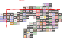
--New 22x33 map.--
- Height of Central Borehamwood is in fact 33. I have added scouted locations below, but the template needs to be extended. --Tybalt Peroni 11:13, 29 October 2008 (UTC)
- I'd like to see your data. I suspect it's 36 in north-south dimension, combining my own observations with others. Would like to have the dimensions confirmed. -- Maunder 15:28, 29 October 2008 (UTC)
- Two independent people have counted 33, I think this is the correct height. My data consists of two sets of iwitness links listed higher up the page, and one screenshot I uploaded. The map below also contains data from screenshots linked here by other people. --Tybalt Peroni 16:12, 29 October 2008 (UTC)
- Yes, I agree. My combined map shows 33 squares vertical for west borehamwood. Yay! -- Maunder 17:45, 29 October 2008 (UTC)
- I'd like to see your data. I suspect it's 36 in north-south dimension, combining my own observations with others. Would like to have the dimensions confirmed. -- Maunder 15:28, 29 October 2008 (UTC)
I believe the map below has errors. The Akehurst Museum should be east of the Whitty Museum. -- Maunder 15:28, 29 October 2008 (UTC)
- Let's hope this is not the case - it would be quite painful to figure out what is wrong and what is right. The part you describe was entered based on the screenshot provided by Zolt today (see higher up the page, Image:CentralBorheam2.png). --Tybalt Peroni 16:13, 29 October 2008 (UTC)
- I am guessing my data was wrong, so I've corrected the few of my squares that did not agree with the pictures above. Thanks, it's lookin pretty good now! -- Maunder 18:23, 29 October 2008 (UTC)
- I think my map could have errors cause I had lots of problems getting and linking all the screenshots and some got missing, but I'm pretty sure about akehurst and Whitty cause it's where I started. It's confirmed by Jen's map and by Tybalt's iwitty n°17. -- Zolt 19:13, 29 October 2008
It definately 22 across by 33 down, managed to tie all the screenshots together and I have personally comfirmed the SW corner. If someone could get a grid up I could fill out the northern, southern and western borders. ~ alphastarre 29th oct 5pm


