East Borehamwood
| Region of East Borehamwood | |||||||||||||||||||||||
| |||||||||||||||||||||||
| Update East Borehamwood's Danger Level | |||||||||||||||||||||||
Known groups in this region:
| |||||||||||||||||||||||
| Phone Mast: |

|
Please remember to keep this article neutral. |
East Borehamwood is a suburb of Borehamwood.
Resource Buildings
|
Fire Stations
|
Hospitals
|
|
Police Stations
| |
|
Shopping Centres |
Billboards |
Paynterton Radio
Recent News
Please: recent news at the top (signed & NPOV). Old news can be archived.
October 2008
31 October 2008
Here is some confirmation of East Borehamwood's NW and SW corners.
First, the Northwest corner: North Central Northeast East
The Southwest Corner: Central South East Southeast
Based on these coordinates, the western border of East Borehamwood is 33 high. --Zarneverfike 05:10, 31 October 2008 (UTC)
28 October 2008
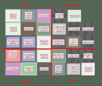
The mapping of this suburb has begun! (note that coorindates are not known for locations below)
-- got two iwitness shots of the lower lefthand corner. http://iwrecords.urbandead.info/10-28-08_2300hrs_PUBLIC/OUT_566-63__0c1-70b-028.html is from inside east borehamwood on the border of central. Second one is from central http://iwrecords.urbandead.info/10-28-08_2300hrs_PUBLIC/OUT_565-64__a37-9b4-a0a.html, reeves library is the south west corner of east borehamwood. --Allenzalone 23:27, 28 October 2008 (UTC)
-- not sure how your ment to help with the map but i have a screen shot of the area I was in before I ran out of AP hope it helps http://img207.imageshack.us/img207/7734/eastrq2.jpg --Manning 21:36, 28 October 2008 (UTC)
--The far Northwestern square of East Borehamwood is the Marcary Museum, orient the map from there. The garage (currently location 13) will not connect to the Bane Building or Lessey Monument if the map is larger than 10x10. --
Iwitness: (16 links) --Janus Abernathy 16:32, 28 October 2008 (UTC)
- all done @User:Duke Garland/BHW --~~~~ [talk] 22:23, 28 October 2008 (UTC)
--- Well, Borehamwood's a hell of a town!Check this screenshot. Janjones 20:48, 28 October 2008 (UTC)
Another shot of what the border looks like. (It's a tower that's at 3 across, 2 down, not a garage).
--Jen 21:50, 28 October 2008 (UTC)
--Look at Central Borehamwood's new map template 22x22, and feel free to use it. Our suburb is confirmed to be 22 blocks wide, although the height is still undetermined. Hopefully all suburbs are of similar dimensions.--
- Central Borehamwood's confirmed dimensions are now 22 wide X 33 high. Eastern Borehamwood's dimensions appear to be the same.
Suburb Map
--I'm posting the new 22x33 suburb map, when you find a corner, fill it in and we'll map inwards from there.--
