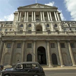
Cattle Bank
| Cattle Bank
Gibsonton [84, 26]
Basic Info:
|
Cattle Bank
Description
Cattle Bank, as you can tell by the picture, is one of oldest banks in Malton, it was origanlly build by Earl Von Strasenburg's great-great-great grandfather (Also called earl Von Strasenburg) in the summer of 1829. It made it's money of the factory workers, by offering them loans with a very low APR (between 0.5% and 1.4%). After the rise in tourism, the focus of Cattle bank changed, it began to make a large percentage of it's money from sellingthe British pound for the American Dollar (as most of the tourists hailed from the states) at 1 pound to 1.4 dollars, meaning they made a huge profit, they would buy an American dollar for 36 pence (our version of the "cent" for those who don't know).
After the current Earl Von Strasenburg's father was killed by a zombie in the early outbreaks, he inhierited all the banks his father owned, and continues to up-hold the tradition of low intrest loans to the poor, and ridiculous prices for British pounds from the yankee tourists.
History
12th October-Cattle bank becomes the base for The Bankers Of Gibsonton-- User:Oldharry101---14:45, 12th october 2008
Barricade Policy
EHB as according to the Gibsonton UBP
Current Status
Light and at HB-- User:Oldharry101---14:46, 12th October
| This page, Cattle Bank, is a locations stub. Please help us to improve the wiki by contributing to this page. Be sure the following information is added to the page: coordinates, suburb, 9 block map (or 16 block map for large buildings), description, barricading policy, and history. Please refer to the Location Style Guide. |
