West Borehamwood
| Suburb of West Borehamwood | ||||||||||||||||||||||||||||||||||||||||||||||||||||||||||||||||||||||||||||||||||||||||||||||||||||||
| ||||||||||||||||||||||||||||||||||||||||||||||||||||||||||||||||||||||||||||||||||||||||||||||||||||||
| Update West Borehamwood's Danger Level | ||||||||||||||||||||||||||||||||||||||||||||||||||||||||||||||||||||||||||||||||||||||||||||||||||||||
|
| ||||||||||||||||||||||||||||||||||||||||||||||||||||||||||||||||||||||||||||||||||||||||||||||||||||||
| View full-city Danger Center | ||||||||||||||||||||||||||||||||||||||||||||||||||||||||||||||||||||||||||||||||||||||||||||||||||||||
| ||||||||||||||||||||||||||||||||||||||||||||||||||||||||||||||||||||||||||||||||||||||||||||||||||||||
| ||||||||||||||||||||||||||||||||||||||||||||||||||||||||||||||||||||||||||||||||||||||||||||||||||||||
Known groups in this suburb:
Key buildings in West Borehamwood:
| ||||||||||||||||||||||||||||||||||||||||||||||||||||||||||||||||||||||||||||||||||||||||||||||||||||||
| Suburb Number: 40 |

|
Please remember to keep this article neutral. |
West Borehamwood is a suburb of Borehamwood, located to the far east end of the city.
Resource Buildings
|
Fire Stations |
Hospitals |
|
NecroTech Facilities {{{NTs}}} |
Police Departments |
|
Malls |
Bulletin Boards |
|
Revive Points |
Paynterton Radio
Recent News
Please: recent news at the top (signed & NPOV). Old news can be archived.
October 2008
October 29th 2008
West Borehamwood suburb is confirmed to be 24 or more in width, and possibly 33 in heigth. Notable features include a north-south railroad line, which continues into NW and SW borehamwood suburbs, and a large amount of fields to the west. None of the scouting patrols sent beyond those fields have returned so far.
- From combining your data with mine, it appears West Borehamwood is 24 (east-west) x 36 (north-south) in dimension. That might suggest Central is also 36 in north-south dimension, but haven't seen the other maps out there yet. -- Maunder 14:28, 29 October 2008 (UTC)
Scouting mission report:
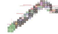
Scribbled some coordinates in red based for latitude on Central Borehamwood known locations, and for longitude from East edge, assuming 22 width, which turned out to be wrong. Red lines are borders with SW and Central Borehamwood (assuming straight lines)
--Zolt 9:13, 29 October 2008 (UTC)
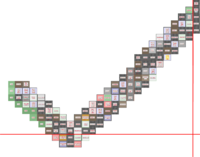
- Seeing the above has prompted me to document my own exploration in a similar fashion. It is possible that I was the Zombie sitting on the Petrol Station in your image, as I was there for a while (and attacked by two people, healed by one).
- My image:
- And a mix of my image with Zolt's, above (based on locations we both visited):
- I noted where I crossed over into Countryside to the West, and Southwest Borehamwood to the South (in both images).
- --Diwen 11:25, 29 October 2008 (UTC)
- Also, this confirms that West Borehamwood is 24 in width if it is indeed rectangular (and it likely is).
- Sorry it sucks and is ugly, but here's my image. I don't think there's any intersection with your images. At least I found some borders.
- Where did the Elstree connection come from in the surrounding suburbs grid at the top? We've all found nothing but Countryside west of here. Balfa 14:45, 29 October 2008 (UTC)
- Awesome work Balfa! I combined Diwen's map with yours, and another scan along the east side that links the two. Burb dimensions are confirmed: 24x33! Now to get all that onto the real map!--Zolt 18:41, 29 October 2008 (UTC)
- Error creating thumbnail: File with dimensions greater than 12.5 MP
October 28th 2008
The mapping of this suburb has begun! Coordinates are currently unclear so the currently mapped area may be inaccurate with regards to position within the suburb. --Bigmaddrongo 13:21, 28 October 2008 (UTC)
Here's another piece of the West Borehamwood Puzzle: West borehamwood map 2--Steampenguin 19:52, 28 October 2008 (UTC)
- peeple, make iwittness shots and i'll do the wiki magic. this feels like monroeville mapping madness take 2 :P --~~~~ [talk] 22:34, 28 October 2008 (UTC)
--Look at Central Borehamwood's new map template 22x22, and feel free to use it. Our suburb is confirmed to be 22 blocks wide, although the height is still undetermined. Hopefully all suburbs are of similar dimensions.--
Suburb Map
Replaced the 10x10 map by a 24x33 template that I did - not sure if it's 100% correct. Marked the first few locations, the rest is up to you, I need some food and sleep. The last row is a bit fked up, anyone feel free to edit the template.
--Zolt 13:20, 29 October 2008 (UTC)
- I would recommend against anyone putting a lot of effort into creating the templates and entering data into them until we actually know the dimensions for sure. After seeing the data posted here, I think West Borehamwood is 24 x 36. If someone else confirms this, then by all means, start your templates! Of course, if other suburbs don't have consistent dimensions, the templates aren't as useful... -- Maunder 15:16, 29 October 2008 (UTC)
- Nah, it's 24x33 and anyway, templates are eeezy. People, we got ourselves a map!
--Zolt 18:48, 29 October 2008 (UTC)
Template:West Borehamwood Suburb


