Ryley Road Police Department: Difference between revisions
AndyMatthews (talk | contribs) |
|||
| (15 intermediate revisions by 7 users not shown) | |||
| Line 1: | Line 1: | ||
{{User:DangerReport/{{PAGENAME}}}} | |||
{{Locationblock| | {{Locationblock| | ||
suburb=Brooke Hills| | suburb=Brooke Hills| | ||
| Line 12: | Line 13: | ||
S_location=[[the Griff Museum]]|S_color=Museum| | S_location=[[the Griff Museum]]|S_color=Museum| | ||
SE_location=[[St. Wulfstan's Hospital]]|SE_color=Hospital}} | SE_location=[[St. Wulfstan's Hospital]]|SE_color=Hospital}} | ||
[[File:Mpd.png|150px]] | |||
===Description=== | ===Description=== | ||
The Ryley Road Police Department is a 2 story yellow-stone building with basement and surrouding parking lot. With its central position between [[Shipp_Alley_Railway_Station| Shipp Alley Railway Station]], [[The_Griff_Museum| The Griff Museum]] and [[St._Wulfstan%27s_Hospital| St. Wulfstan`s Hospital]] it plays a important role for survivors in the area who are stopping by to rest. | |||
===Barricade Policy=== | ===Barricade Policy=== | ||
Following [[Brooke_Hills_Barricade_Plan| Brooke Hills Barricade Plan]] and [[BHODP| Brooke Hills Optimal Defense Plan]] the Ryler Road Police Station should at all times be very heavily barricaded (VHB) or more. | |||
===History=== | |||
Ryley Road Police Department was founded in 1949 after a wave of crime had hit the suburbs of [[Brooke_Hills| Brooke Hills]]. Spending the early years with street patrols it quickly developed to riot control due to the unstable conditions in brooke hills. Cause of its position it also took most of Twitt's cases (Also due to theyr incompetence). | |||
Once the infection hit the Police Station played a vital role in the evacuation of the victims through the trainstation. | |||
<br style="clear: both" /> | |||
== | ==Malton Department of Emergency Management Information== | ||
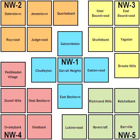
[[Brooke Hills]] is in District Three of the [[Department of Emergency Management#NW Division|Northwest Division]] of the Department of Emergency Management. | |||
[[File:DEM NW.JPG|DoEM NW Division Three]] | |||
---- | ---- | ||
{{locations-stub}} | {{locations-stub}} | ||
[[Category:Brooke Hills]] | [[Category:Brooke Hills]] | ||
[[Category:Police Departments]] | [[Category:Police Departments]] | ||
Latest revision as of 06:06, 23 October 2024
| Ryley Road Police Department |
| Ryley Road Police Dept
Brooke Hills [42,26]
Basic Info:
|
Description
The Ryley Road Police Department is a 2 story yellow-stone building with basement and surrouding parking lot. With its central position between Shipp Alley Railway Station, The Griff Museum and St. Wulfstan`s Hospital it plays a important role for survivors in the area who are stopping by to rest.
Barricade Policy
Following Brooke Hills Barricade Plan and Brooke Hills Optimal Defense Plan the Ryler Road Police Station should at all times be very heavily barricaded (VHB) or more.
History
Ryley Road Police Department was founded in 1949 after a wave of crime had hit the suburbs of Brooke Hills. Spending the early years with street patrols it quickly developed to riot control due to the unstable conditions in brooke hills. Cause of its position it also took most of Twitt's cases (Also due to theyr incompetence).
Once the infection hit the Police Station played a vital role in the evacuation of the victims through the trainstation.
Malton Department of Emergency Management Information
Brooke Hills is in District Three of the Northwest Division of the Department of Emergency Management.
| This page, Ryley Road Police Department, is a locations stub. Please help us to improve the wiki by contributing to this page. Be sure the following information is added to the page: coordinates, suburb, 9 block map (or 16 block map for large buildings), description, barricading policy, and history. Please refer to the Location Style Guide. |

