Talk:South Monroeville
AUTOMAPPING
Alex DeWitt of the DEM has made an AutoMapping extension - please download it and check the current results here (note that the map is updated from the results every five minutes and you may have to allow ud-malton.info to install the addon before it works) --xensyriaT 06:34, 27 February 2008 (UTC)
Let's Do This Right
This time around let's do suburbs right please, I've moved the Barricade Plan and Recent News sections to this talk page. Barricade plans tend to cause more problems than they fix and in a city with no NTs those problems are only increased many times over. It's tactics, discuss it here if you wish. As for Recent News, well, we can work on a better system for that ;).--Karekmaps?! 17:42, 25 February 2008 (UTC)
- So do it. --VI 18:04, 25 February 2008 (UTC)
Recent News
Remember to keep news entries NPOV for this Suburb page.
Don't be a nobody - sign your posts!
February 2008
February 25rd
First Draft layout for South Monroeville. Please add to the page as you can - it obviously needs all the help it can get! User:Suze/Sig 11:29, 25 February 2008 (UTC)
Barricade Plan & On the Ground Observations
Gather lengths of pipe from warehouses.--Warlord zephyr 13:42, 25 February 2008 (UTC)
- No dont. Early zeds cant open doors :P but they can break down barricades. In the beggining you are better off not barricading Cisisero 13:55, 25 February 2008 (UTC)
- However brought down barricades leave the door shut, so nothing wrong with l.o.p. --Theokrat 15:35, 25 February 2008 (UTC)
- Exept the exp gained which can then be spent on memorys of life? --Dirk triggerfinger 16:32 25 February 2008 (GMT)
Does anyone know if the IP hits on this map count toward the other one as well?--Srg Shawn 17:01, 25 February 2008 (UTC)
Yes, they do. --Dirk triggerfinger 17:27 25th Feruary 2008 (GMT)
D'oh, guess I shot myself in the foot with that one.--Srg Shawn 17:44, 25 February 2008 (UTC)
I'm here at Zeliak Way Police Dept. 36 surivors with a generator running. Some zombie action to the northwest, but nothing to bother us here. There's a hospital directly south of this police department. Looks like a good place do base a defense around, but we're already VSB.Alpha 0ne 22:43, 28 February 2008 (UTC)
Survivor status
South Monroeville seems to contain the first recorded building powered by a generator: Colliver Grove Police Station
Mapping
I started mapping the NE corner of South Monroeville. This map latches onto Central Monroeville by Lohrmann building being due south of the Bock Building and Dennis Library south of Grant Avenue. (FS = fire station. Bdg = building. Bvd = boulevard)
Bock bdg (in Central Monroeville)-                   -                     -                 - Grant Avenue
Lohrmann Bdg - Stauffer Walk     - Tomlinson Alley   - Munson Plaza School - The Sisson Bar  - Dennis Library - (City Limit)
?            - The Olin Monument - Kindelberger Road - Gerrish Bank        - Lynch Towers    - Work Grove FS
?            - ?                 - Lent Bdg          - Peacock Avenue FS   - Fall Museum     - Warren Blvd
?            - ?                 - ?                 - Presley Alley       - Bigham Avenue   - Ross Hotel
Skrofler 16:11, 26 February 2008 (UTC)
Well, I've stumbled across the east border and south border of South Monroeville. Stimms McCleary was at that same corner, so I'm obviously not the first survivor down here. I have no GPS unit (but I do have a camera!) but the source reveals my location to possibly be --399-99-- 398-99. I ended up trudging through some woodlands and a lot of fields. I'll work up a spreadsheet of my path in a little bit - all I can say now is that South Monroeville is at least 30 wide.--Mikelietz 19:36, 25 February 2008 (UTC)
- im going to scout horizontally, and post here. Hopefully we can piece this puzzle together quickly.--RosslessnessWant a Location Image? 20:04, 25 February 2008 (UTC)
- Im at the ne of south monroeville.
Top row of south Monroeville in part (w to e) is stauffer walk Tomlinson alley, munson plaza school, the sisson bar, dennis library, edge of map
Below that the olin monument kidelberger road, gerrish bank, lynch towers. Work grove fire station, edge of map.
And below that, the harrold bar the lent building, peacock avenue fire station, the fall museum, warren blvd, edge of map.
Below that a carpark the hester bar presley alley bingham alley the ross hotel east of map
Below that the Jennings grove school, Winston bank, a junkyard, otto grove bowles monument east of map
Below that Derbyshire avenue school Hedrick cinema wasteland the maston bar mcCulloch grove east of map. --RosslessnessWant a Location Image? 20:45, 25 February 2008 (UTC)
- OK, I was wrong before. At one or two points I actually stepped out of the city, though the corner of 399,99 is South Monroeville. Here's my spreadsheet: South Monroeville--Mikelietz 21:18, 25 February 2008 (UTC)
- Just updated this with the one I linked below.--Mikelietz 03:42, 26 February 2008 (UTC)
User:Karek/ProjDev/PD13MVMPPT06, No one's done anything with my stuff yet, I'll probably add more too it tomorrow. It's set up by x,y coords which are listed there so it can actually be merged with the other maps. --Karekmaps?! 21:43, 25 February 2008 (UTC)
Found a lighted factory, [355,59]--Mikelietz 00:37, 26 February 2008 (UTC)
- Found a cell tower, Childs Square [354,57]--Mikelietz 00:44, 26 February 2008 (UTC)
- Found 4 police departments in a 4x4 area... must be high crime.--Mikelietz 00:59, 26 February 2008 (UTC)
Another survivor started this map but I can't remember their name, so I'll ask in the place I'm in then add it in if they respond (or they can change it here if they'd like). I explored a little further and added some more blocks to it, then added coordinates. Hope it helps! South Monroeville --Fifth Element 12:22, 26 February 2008 (UTC)
Zombies!
There appear to be more zombies here than anywhere else. I have encountered about 5 in 75 AP--Warlord zephyr 20:15, 25 February 2008 (UTC)
I'm surprised. I spent about 40 aps walking around south Monroeville and only saw two zombies.--Srg Shawn 20:48, 25 February 2008 (UTC)
Some mapping...
http://img.photobucket.com/albums/v180/TheUncleBob/minimap.jpg
mapping
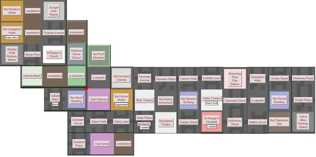
more mapping, with coordinates, for S. Monroeville:

385-65 = Walers Boulevard      386-65 = a carpark                    387-65 = a warehouse          388-65 = Lyon St Fire Station
385-66 = Bowell Cinema         386-66 = Yohn Avenue Railway Station  387-66 = Kohr Street School   388-66 = Beauchamp Library
385-67 = McDivett Towers       386-67 = Wilmuth Bank                 387-67 = Cartwright Drive     388-67 = Piscator Crescent

389-65 = Brandon Square        390-65 = McElwee Ave
389-66 = the Haynes Bar        390-66 = Harold Square                391-66 = a junkyard
389-67 = the Pullen Museum     390-67 = Philip General Hospital      391-67 = Wegner Drive
389-68 = the Rush Museum       390-68 = St. Julius's Church          391-68 = a cemetery
these aren't in their exact layout, I just did this to save wikispace and for general readability --Razi.
South Monroeville - 75 x 388 y = a field please see http://img212.imageshack.us/my.php?image=ud01iz8.jpg --Sensodyne 14:34, 18 March 2008 (UTC)
- Thanks! I've added it to DB and shall add it to the map a bit later (there's some more stuff needing updates queued) --~~~~ [talk] 19:44, 18 March 2008 (UTC)
Special Buildings
I just found a stadium, which seems to be on a University Campus, as it has residences which are described as belonging to the University. It's bordered by woodland to the west. --Funt Solo QT ![]() 21:00, 27 February 2008 (UTC)
21:00, 27 February 2008 (UTC)
- Further south theres a barn, and a swimming pool. looks like a lot of the terraforming ideas put up over the years are in place. I hope my helipads somewhere.--RosslessnessWant a Location Image? 21:01, 27 February 2008 (UTC)
More mapping
This is the area around where I spawned on signing up...
383-46 –                 :: 384-46 –                              :: 385-46 –                            :: 386-46 –                      :: 387-46 – the Pielemeier Building     :: 388-46 – Driscoll Boulevard   :: 389-46 – Criswell Square
383-47 –                 :: 384-47 –                              :: 385-47 –                            :: 386-47 – the Payne Motel      :: 387-47 – the Speitel Hotel           :: 388-47 – the Shewman Building :: 389-47 – Redlon Boulevard
383-48 –                 :: 384-48 – Williams Way Railway Station :: 385-48 – the Lynn Hotel             :: 386-48 – the Songer Monument  :: 387-48 – Anastasius General Hospital :: 388-48 – Cochran Alley        :: 389-48 – Meloy Grove School
383-49 – a factory       :: 384-49 – the Paxton Hotel             :: 385-49 – Inlow Road Railway Station :: 386-49 – the Wermuth Building :: 387-49 – McKeeman Bank               :: 388-49 – Club Foxworthy       :: 389-49 –
383-50 – McMullen Towers :: 384-50 – Done Road Fire Station       :: 385-50 – the Parker Building        :: 386-50 – Buchanan Park        :: 387-50 – Kerr Alley                  :: 388-50 – Ehrman Lane          :: 389-50 –
383-51 - wasteland       :: 384-51 – Arwine Avenue                :: 385-51 – wasteland                  :: 386-51 – Mavity Plaza School  :: 387-51 – the Bloxome Monument        :: 388-51 –                      :: 389-51 –
Hope this helps! Dinoguy1000 02:34, 28 February 2008 (UTC)
- Before I forget: I don't actually know if Criswell Square is actually a part of South Monroeville or a neighboring neighborhood, in the event anyone in the area cares to check. Dinoguy1000 02:47, 28 February 2008 (UTC)
- I'm aware of that... In fact, I installed Firefox on this computer specifically for it. However, I also posted this information for the benefit of anyone working on a wiki version of the map, unless the automap author plans on doing a formatted dump of the map information once it's complete and posting it him/herself. Dinoguy1000 02:55, 28 February 2008 (UTC)
- Ah, okay. Can you just get this info directly from the page source of the automap, or do we have to wait for the author to do this "formatted dump". I'm not familiar with that term. --PdeqTalk* 04:52, 28 February 2008 (UTC)
- You could, although the automapper doesn't seem to collect any information on individual suburbs (at least, there's no such information present in the page source)... Although, if the borders between suburbs could be definitively pinned down, that problem would be a rather moot one. Dinoguy1000 18:34, 1 March 2008 (UTC)
- Here is where there is much discussion going on about suburb borders. --PdeqTalk* 22:32, 1 March 2008 (UTC)
- Actually for the UD pages it should be in the source code, probably with a defined variable/class as I know it has different font from the rest of the page and is also modified by numerous different Firefox Extensions. That and I also know, form the extension creator himself having said so, that the Automapper does collect the suburb data. I believe he said he was going to be adding it soon, if it hasn't already been done.--Karekmaps?! 04:28, 2 March 2008 (UTC)
- You could, although the automapper doesn't seem to collect any information on individual suburbs (at least, there's no such information present in the page source)... Although, if the borders between suburbs could be definitively pinned down, that problem would be a rather moot one. Dinoguy1000 18:34, 1 March 2008 (UTC)
- Ah, okay. Can you just get this info directly from the page source of the automap, or do we have to wait for the author to do this "formatted dump". I'm not familiar with that term. --PdeqTalk* 04:52, 28 February 2008 (UTC)
- I'm aware of that... In fact, I installed Firefox on this computer specifically for it. However, I also posted this information for the benefit of anyone working on a wiki version of the map, unless the automap author plans on doing a formatted dump of the map information once it's complete and posting it him/herself. Dinoguy1000 02:55, 28 February 2008 (UTC)
how big is this suburb
well where are the edges? --Theokrat 19:00, 28 February 2008 (UTC)
- The Northern Border is at y = 47. --PdeqTalk* 18:08, 29 February 2008 (UTC)
- Any info on the other edges? It seems that there is nothing to the east, correct? --Theokrat 20:56, 29 February 2008 (UTC)
united map
i've made a huge update to my united map: top half, bottom half. if you have data lacking there - i'll be glad to parse it in. i'm also looking forward to parse out any sub-blocks of the map in any suitable format to be placed on wiki pages. --~~~~ [talk] 00:10, 29 February 2008 (UTC)
Basic maps gone
It is now just replaced with a small picture, lacking linsk to the other adjacent suburbs.--Kolechovski 18:24, 25 March 2008 (UTC)
- Yes, but that is temporally --~~~~ [talk] 19:46, 25 March 2008 (UTC)
- Tis better now, but could we somehow blow up the picture a bit? That text is insanely small...--Kolechovski 18:51, 29 March 2008 (UTC)
Proposed Barricade Plan
Map Legend: Yellow=VSB building, Red=EHB building, Blue=VSB if the area is relatively safe, or EHB if dangerous
South Monroeville Barricade Plan (western half): http://img523.imageshack.us/my.php?image=southwestmonroevillecadry9.gif
South Monroeville Barricade Plan (eastern half): http://img523.imageshack.us/my.php?image=southeastmonroevillecadws7.gif
Does everybody likey?--Kolechovski 23:50, 1 April 2008 (BST)
- I likey because it means I don't have to scout as I burst out of my ruins and crack survivor heads open. --
 .
.
 . <== DDR Approved Editor 23:54, 1 April 2008 (BST)