  

Scent Coordinates
|
(5,5)_,(16,5)_, (27,5)_,|| (38,5)_, (50,5)_, (61,5)_,|| (72,5)_, (83,5)_,(94,5)_
(5,16),(16,16), (27,16),|| (38,16), (50,16), (61,16),|| (72,16), (83,16),(94,16)
(5,27),(16,27), (27,27),|| (38,27), (50,27), (61,27),|| (72,27), (83,27),(94,27)
(5,38),(16,38), (27,38),|| (38,38), (50,38), (61,38),|| (72,38), (83,38),(94,38)
(5,50),(16,50), (27,50),|| (38,50), (50,50), (61,50),|| (72,50), (83,50),(94,50)
(5,61),(16,61), (27,61),|| (38,61), (50,61), (61,61),|| (72,61), (83,61),(94,61)
(5,72),(16,72), (27,72),|| (38,72), (50,72), (61,72),|| (72,72), (83,72),(94,72)
(5,83),(16,83), (27,83),|| (38,83), (50,83), (61,83),|| (72,83), (83,83),(94,83)
(5,94),(16,94), (27,94),|| (38,94), (50,94), (61,94),|| (72,94), (83,94),(94,94)
|
Full City Map
NorthWest Malton
North Malton
NorthEast Malton
West Malton
Central Malton
East Malton
SouthWest Malton
South Malton
SouthEast Malton
Instructions
To add an image
Reference the Scent Coordinates chart to find the appropriate section. Click the coordinates on the chart to go to the wiki page for that location or click on the image on the map you wish to replace and upload a new version of the file. Please try to keep the new image at roughly the same aspect ratio as the old and upload in .PNG file format. Uploading a file will change the image as it is displayed on the map and on the wiki page for the location from which the scan was taken. Please replace the signature of the previous field agent on the location page with your own signature.
News Template
If you wish to post to the suburb news page to let survivors know that the data has been updated, the following template has been provided. For instructions on its use, see here.
{{Zscentscan
|location=5,5
|zombies=some number of
|newstext=No centralized groups present
|user=--~~~~}}
To see the age of an image
Click on the image to go to the sumary page for it. The date that the image was uploaded will appear on the page.
To read the scans
Suburbs
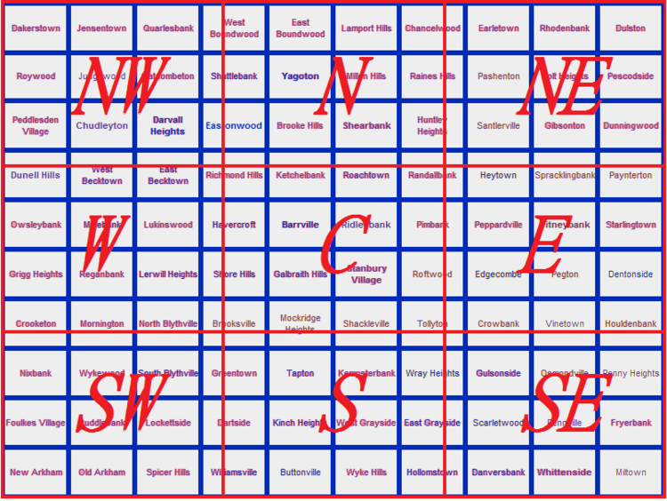
The map is not separated by suburb. Suburbs are 10 blocks square while scent maps are 11 blocks square. These scent maps break the city into 9 even segments composed of NorthWest, North, NorthEast, West, Central, East, SoutWest, South, SouthEast. The central coordinants that compose these segments are listed in the coordinant map that follows. There is an unscanned area that is one block wide and quadrisects the city E/W and N/S. Otherwise the map is complete. To convert to suburbs, please see the following chart.

Numbers
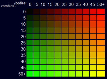
Scan values are displayed in terms of red and green chroma values. The brighter green, the more zombies. The brighter red, the more dead bodies. Brown, tan, and yellow squars contain a mixture of the two. More detailed data on specific conversion to numeric values can be found HERE and a general color key lifted from a similar map is reproduced below.

Location
Each colored square represents a block in Malton. The coordinates listed on the Scent Coordinate chart above are represented by green stars on the scans. Use a map to triangulate a location by working off of these points.
Other Scent maps
The ZALP map is by no means the first map of its kind. Other maps such as the Omnimap [Please note that neither the Omnimap nor the Scenteral Intelligence Map are still used. Catherine Cushing (talk) ] have put forth similar ideas and certain groups make use of proprietary in-house maps. These maps incorporate a more flexible data input system than the one on this page though some require the installation of certain scripts to update efficiently. The advantage of the ZALP map is its accessibility (it is easily updatable and requires no script to use) and its efficiency (requiring fewer than 20 days for a single individual to update the entire city map). The guiding principle being that, in order for a map like this to have value, it must be updated by the greatest number of people possible, as frequently as possible. To this end, the simpler the better. That said, this is a resource not a competitor: users should feel free to use data from this map to update the others if they wish.
|