Starlingtown: Difference between revisions
| Line 79: | Line 79: | ||
{{NWnews | {{NWnews | ||
|building={{NWnlink|the Veryard Building}} | |building={{NWnlink|the Veryard Building}} | ||
|zombies= | |zombies=6 | ||
|newstext=Building up and barricaded. Big survivor presence. Power and radio. | |newstext=Building up and barricaded. Big survivor presence. Power and radio. | ||
|user=[[User:Itsacon|Itsacon]] 17:50, 21 October 2009 (BST) | |user=[[User:Itsacon|Itsacon]] 17:50, 21 October 2009 (BST) | ||
}} | }} | ||
====October 8<sup>rd</sup>==== | ====October 8<sup>rd</sup>==== | ||
Members of the South Paynterton Aces should begin be returning from the Tolman Power Station raid in the next few days. --[[User:Jay the Irishman|Jay the Irishman]] 06:38, 9 October 2009 (BST) | Members of the South Paynterton Aces should begin be returning from the Tolman Power Station raid in the next few days. --[[User:Jay the Irishman|Jay the Irishman]] 06:38, 9 October 2009 (BST) | ||
Revision as of 16:59, 21 October 2009
| Suburb of Starlingtown | ||||||||||||||||||||||||||||||||||||||||||||||||||||||||||||||||||||||||||||||||||||||||||||||||||||||||||||||||||||||||||||||||||||||||||||||||||||||||||||||||||||||||||||||||||||||||||||||||||||||||||
| ||||||||||||||||||||||||||||||||||||||||||||||||||||||||||||||||||||||||||||||||||||||||||||||||||||||||||||||||||||||||||||||||||||||||||||||||||||||||||||||||||||||||||||||||||||||||||||||||||||||||||
| Update Starlingtown's Danger Level | ||||||||||||||||||||||||||||||||||||||||||||||||||||||||||||||||||||||||||||||||||||||||||||||||||||||||||||||||||||||||||||||||||||||||||||||||||||||||||||||||||||||||||||||||||||||||||||||||||||||||||
|
| ||||||||||||||||||||||||||||||||||||||||||||||||||||||||||||||||||||||||||||||||||||||||||||||||||||||||||||||||||||||||||||||||||||||||||||||||||||||||||||||||||||||||||||||||||||||||||||||||||||||||||
| View Danger Center | ||||||||||||||||||||||||||||||||||||||||||||||||||||||||||||||||||||||||||||||||||||||||||||||||||||||||||||||||||||||||||||||||||||||||||||||||||||||||||||||||||||||||||||||||||||||||||||||||||||||||||
| ||||||||||||||||||||||||||||||||||||||||||||||||||||||||||||||||||||||||||||||||||||||||||||||||||||||||||||||||||||||||||||||||||||||||||||||||||||||||||||||||||||||||||||||||||||||||||||||||||||||||||
| ||||||||||||||||||||||||||||||||||||||||||||||||||||||||||||||||||||||||||||||||||||||||||||||||||||||||||||||||||||||||||||||||||||||||||||||||||||||||||||||||||||||||||||||||||||||||||||||||||||||||||
Known groups in this suburb:
Key buildings in Starlingtown:
| ||||||||||||||||||||||||||||||||||||||||||||||||||||||||||||||||||||||||||||||||||||||||||||||||||||||||||||||||||||||||||||||||||||||||||||||||||||||||||||||||||||||||||||||||||||||||||||||||||||||||||
| Suburb Number: 50 |

|
Please remember to keep this article neutral. |
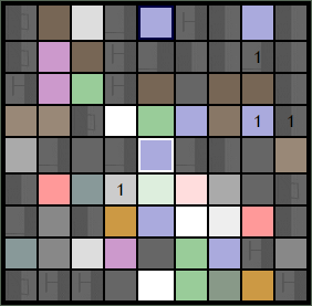
Starlingtown is a suburb of Malton, located in the east of the city. It is one of the few upper class suburbs on the east end. With little to no crime rate, Starlingtown does not have a police station, and relied upon neighboring precincts to enforce the law. The Starlingtown skyline is distinguished with its several business buildings and was known for its socialite nightlife in its many clubs.
Resource Buildings
|
Fire Stations
|
Hospitals
|
|
NecroTech Facilities
|
Police Departments
|
|
Malls
|
Bulletin Boards
|
|
Revive Points
|
Phone Mast
Veazey Towers [95, 46]
Starlingtown Information Resources
The Starlingtown Building Information Center contains status reports and updates on key buildings in the suburb.
View zombie activity and locations in Starlingtown from External Military Reports and NecroWatch.
Revivification Requests
Anyone looking for a revive in Starlingtown should head to the North Cemetery [93, 43]. The South Paynterton Aces service this revive point regularly so just kick back and relax (shoes shined while you wait). They also hand out revives at the South Cemetery [94, 47] too, but somewhat less frequently. Post revive requests on their forum and they'll come help!
Recent News
Please: recent news at the top (signed & NPOV). Old news can be archived.
October 2009
October 21st
 |
NecroWatch |
|
NecroWatch reported in from the Veryard Building. The scan revealed 6 zombies within the scanning range of the facility. Building up and barricaded. Big survivor presence. Power and radio. |
October 8rd
Members of the South Paynterton Aces should begin be returning from the Tolman Power Station raid in the next few days. --Jay the Irishman 06:38, 9 October 2009 (BST)
October 3rd
25.96 MHz: "... flying over Starlingtown, can see twenty or so on the streets ... mostly just stragglers, no organised groups ... a lot of buildings with lights on ... some minor structural damage ... the Veryard Building has lights on ..." --Ryan Rocksmith 19:06, 3 October 2009 (BST)
Things to do while in Starlingtown
- Quench the thirst for Beer! - The Hartry Arms is open at all hours of the day, 7 days a week, serving free ice-cold beers. What more could you ask for? Nothing, that's what. So drop on by the pub and quench that thirst, play some billiards or darts, and chat it up with some of the friendliest survivors this side of Malton. Close to Club Firminger, you can have a good party!.
- Hurt? No worries, free health care! - St. Alban's Hospital the best place for your health care!
- Party? Where? - In Club Firminger you can have the best party with the Barman Alvaromesa!
- Bacardi? What is that? - Bacardi Company located in Factory 99,44
- Soooo CUTE! - Head on down to The Matthews Museum and spread stuffed animals all across Starlingtown!
Barricade Plan
For more information, please see Starlingtown Barricade Plan.
| LEGEND | ||||||||||||||||||||||
|---|---|---|---|---|---|---|---|---|---|---|---|---|---|---|---|---|---|---|---|---|---|---|
| ||||||||||||||||||||||
| ||||||||||||||||||||||
|
Suburb Map
NT Scans
|

