Starlingtown: Difference between revisions
| Line 69: | Line 69: | ||
{{BurbNewsIntro}} | {{BurbNewsIntro}} | ||
===October 2008=== | ===October 2008=== | ||
====October 31<sup>th</sup>==== | |||
There is a mob of 13 zombies in [[The Veryard Building]]. I'm pretty sure they are not here to do any trick-or-treating. Also, a quick scout shows the safety of the suburb is deteriorating rapidly, so I'm changing the danger level to ''Dangerous''.--{{User:Omega360/Sig}} 11:56, 31 October 2008 (UTC) | |||
====October 29<sup>th</sup>==== | ====October 29<sup>th</sup>==== | ||
The situation in Starlingtown has begun to deteriorate. A handful of zombies from the ruined southeast have found their way up to the suburb. The southern part of Starlingtown is battered, and the zombies are now besieging the core area around Veryard NT. Currently, Flower Walk Fire Station and St. Alban's Hospital are in ruins, and the factory between them has lost power. -- [[User:Jenkem|Jenkem]] 13:09, 29 October (UTC) | The situation in Starlingtown has begun to deteriorate. A handful of zombies from the ruined southeast have found their way up to the suburb. The southern part of Starlingtown is battered, and the zombies are now besieging the core area around Veryard NT. Currently, Flower Walk Fire Station and St. Alban's Hospital are in ruins, and the factory between them has lost power. -- [[User:Jenkem|Jenkem]] 13:09, 29 October (UTC) | ||
| Line 77: | Line 79: | ||
====October 4<sup>th</sup>==== | ====October 4<sup>th</sup>==== | ||
At least 12 zombies on the streets, although 3 of those appear to be Mrh? cows. 4 of the 7 [[Tactical Resource Point]]s are powered (the NTs and the PDs), leaving the single auto repair and the two factories without power. Without any ruination, there's little evidence that the small number of zombies are having any success with break-ins, so leaving this as ''Safe'' for the time being. --<span style="font-size:90%">[[User:Funt Solo|Funt Solo]]</span> <sup style="font-size:70%">[[Mod_Conspiracy|QT]]</sup> [[Image:Scotland flag.JPG|18px]] 17:26, 4 October 2008 (BST) | At least 12 zombies on the streets, although 3 of those appear to be Mrh? cows. 4 of the 7 [[Tactical Resource Point]]s are powered (the NTs and the PDs), leaving the single auto repair and the two factories without power. Without any ruination, there's little evidence that the small number of zombies are having any success with break-ins, so leaving this as ''Safe'' for the time being. --<span style="font-size:90%">[[User:Funt Solo|Funt Solo]]</span> <sup style="font-size:70%">[[Mod_Conspiracy|QT]]</sup> [[Image:Scotland flag.JPG|18px]] 17:26, 4 October 2008 (BST) | ||
==Barricade Plan== | ==Barricade Plan== | ||
Revision as of 11:56, 31 October 2008
| Suburb of Starlingtown | ||||||||||||||||||||||||||||||||||||||||||||||||||||||||||||||||||||||||||||||||||||||||||||||||||||||||||||||||||||||||||||||||||||||||||||||||||||||||||||||||||||||||||||||||||||||||||||||||||||||||||
| ||||||||||||||||||||||||||||||||||||||||||||||||||||||||||||||||||||||||||||||||||||||||||||||||||||||||||||||||||||||||||||||||||||||||||||||||||||||||||||||||||||||||||||||||||||||||||||||||||||||||||
| Update Starlingtown's Danger Level | ||||||||||||||||||||||||||||||||||||||||||||||||||||||||||||||||||||||||||||||||||||||||||||||||||||||||||||||||||||||||||||||||||||||||||||||||||||||||||||||||||||||||||||||||||||||||||||||||||||||||||
|
| ||||||||||||||||||||||||||||||||||||||||||||||||||||||||||||||||||||||||||||||||||||||||||||||||||||||||||||||||||||||||||||||||||||||||||||||||||||||||||||||||||||||||||||||||||||||||||||||||||||||||||
| View Danger Center | ||||||||||||||||||||||||||||||||||||||||||||||||||||||||||||||||||||||||||||||||||||||||||||||||||||||||||||||||||||||||||||||||||||||||||||||||||||||||||||||||||||||||||||||||||||||||||||||||||||||||||
| ||||||||||||||||||||||||||||||||||||||||||||||||||||||||||||||||||||||||||||||||||||||||||||||||||||||||||||||||||||||||||||||||||||||||||||||||||||||||||||||||||||||||||||||||||||||||||||||||||||||||||
| ||||||||||||||||||||||||||||||||||||||||||||||||||||||||||||||||||||||||||||||||||||||||||||||||||||||||||||||||||||||||||||||||||||||||||||||||||||||||||||||||||||||||||||||||||||||||||||||||||||||||||
Known groups in this suburb:
Key buildings in Starlingtown:
| ||||||||||||||||||||||||||||||||||||||||||||||||||||||||||||||||||||||||||||||||||||||||||||||||||||||||||||||||||||||||||||||||||||||||||||||||||||||||||||||||||||||||||||||||||||||||||||||||||||||||||
| Suburb Number: 50 |

|
Please remember to keep this article neutral. |
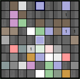
Starlingtown is a suburb of Malton, located in the east of the city. It is one of the few upper class suburbs on the east end. With little to no crime rate, Starlingtown does not have a police station, and relied upon neighboring precincts to enforce the law. The Starlingtown skyline is distinguished with its several business buildings and was known for its socialite nightlife in its many clubs.
Resource Buildings
|
Fire Stations
|
Hospitals
|
|
NecroTech Facilities
|
Police Departments
|
|
Malls
|
Bulletin Boards
|
|
Revive Points
|
Phone Mast
Veazey Towers [95, 46]
Revivification Requests
Imber Square is a Revive Point in Starlingtown featuring regular runs! Anyone waiting at the Imber Square: just sit back and relax! The nearby North Cemetery is a good spot too. The South Paynterton Aces service both sites. They service the South Cemetery too, but somewhat less frequently. Post revive requests on their forum and they'll come help!
Recent News
Please: recent news at the top (signed & NPOV). Old news can be archived.
October 2008
October 31th
There is a mob of 13 zombies in The Veryard Building. I'm pretty sure they are not here to do any trick-or-treating. Also, a quick scout shows the safety of the suburb is deteriorating rapidly, so I'm changing the danger level to Dangerous.-- Ωmega360 ![]() T 11:56, 31 October 2008 (UTC)
T 11:56, 31 October 2008 (UTC)
October 29th
The situation in Starlingtown has begun to deteriorate. A handful of zombies from the ruined southeast have found their way up to the suburb. The southern part of Starlingtown is battered, and the zombies are now besieging the core area around Veryard NT. Currently, Flower Walk Fire Station and St. Alban's Hospital are in ruins, and the factory between them has lost power. -- Jenkem 13:09, 29 October (UTC)
October 24th
Starlingtown remains remarkably safe, though probably not the kind of place where you'd want to sleep outside. There are occasional break-ins at Flower Walk Fire Station, but these are occurring no more frequently than usual. The core buildings around Veryard NT are all caded and lit, and the South Paynterton Aces have their radios up and running at 28.28 MHz. Revive queues at Imber Square and the North Cemetery are so short as to be non-existent. -- Jenkem 16:05, 24 October (UTC)
October 4th
At least 12 zombies on the streets, although 3 of those appear to be Mrh? cows. 4 of the 7 Tactical Resource Points are powered (the NTs and the PDs), leaving the single auto repair and the two factories without power. Without any ruination, there's little evidence that the small number of zombies are having any success with break-ins, so leaving this as Safe for the time being. --Funt Solo QT 17:26, 4 October 2008 (BST)
Barricade Plan
For more information, please see Starlingtown Barricade Plan.
| LEGEND | ||||||||||||||||||||||
|---|---|---|---|---|---|---|---|---|---|---|---|---|---|---|---|---|---|---|---|---|---|---|
| ||||||||||||||||||||||
| ||||||||||||||||||||||
|
Suburb Map
NT Scans
|
